


Le Haut Chamaroux

Chabard
User

Length
17.1 km

Max alt
1468 m

Uphill gradient
508 m
Km-Effort
24 km

Min alt
1202 m

Downhill gradient
507 m
Boucle
Yes
Creation date :
2023-05-18 07:43:09.0
Updated on :
2023-05-19 16:31:30.856
5h17
Difficulty : Medium

FREE GPS app for hiking
 SityTrail
IGN / Geographical institutes
SityTrail Plus
The world is yours!
About
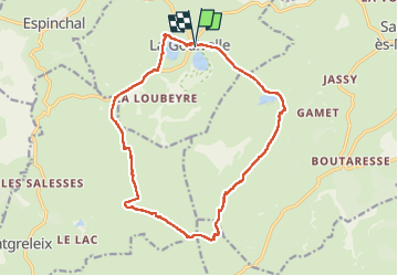
Trail Walking of 17.1 km to be discovered at Auvergne-Rhône-Alpes, Puy-de-Dôme, La Godivelle. This trail is proposed by Chabard.
Description
Le Haut Chamaroux en boucle au départ de la Godivelle
Positioning
Country:
France
Region :
Auvergne-Rhône-Alpes
Department/Province :
Puy-de-Dôme
Municipality :
La Godivelle
Location:
Unknown
Start:(Dec)
Start:(UTM)
494048 ; 5026134 (31T) N.
Comments